Harrow and Hillingdon Geological Society
Slippery Slopes
Home | Monthly Meetings | Field Trips | Exhibitions | Other Activities | Members Pages | Useful Links
The slippery slopes – landslides
Dr David Brook OBE
Landslides are mass movements of soil and/or rock under the influence of gravity. Movement can be slow or rapid and it may be continuous or subject to intermittent surges. The scale of movement can vary from a few tonnes of material affecting only a few square metres to many millions of tonnes affecting several hectares.
Slopes will only move if the forces contributing to movement (affected by removal of lateral or underlying support, overloading, lateral pressure, increase of slope angle or transitory stresses such as earthquakes) exceed the forces resisting movement (affected by composition and texture, effects of pore water, changes in structure such as liquefaction, relict structures such as joints and bedding planes).
Landslides are classified by the size of material involved (rock, debris or soil) and the type of movement involved. Falls are abrupt movement of materials from a steep slope or cliff; slides involve movement along a recognisable shear surface or surfaces, which may be circular (rotational slides), non-rotational (as in block slides, slab slides or spreading failures) or essentially planar (translational slides); flows are rapid mass movements with a high proportion of water or air, which advance as a viscous fluid with movements between grains predominating over shear-surface movements. Complex landslides can include a number of these styles of movement.
Some overseas examples
The more spectacular and life-threatening landslides occur in areas of high relief, which are tectonically unstable. For example, a landslide in 1903 destroyed the town of Frank in Alberta, Canada, and filled the valley floor to an average depth of 20m
On 31 May 1970, a rock and snow avalanche on Mt Huascaran in Peru, which was triggered by an earthquake, buried the towns of Yungay and Ranrahirca, killing over 25,000 people. It travelled along a valley for 14.4km at an average speed of 280km/hour then continued down-valley for a further 50km at 25km/hour.
At Anchorage in Alaska, the entire Turnagain Heights subdivision of was destroyed when the soil liquefied after the Prince William Sound earthquake in 1964. At least 75 houses were destroyed when a block of earth 2.5 km long and 273m wide broke loose and slid 21m towards Cook Inlet.
Landsliding in Britain
In Britain there are lots of little landslides and some more significant ones. Roads and railway lines are regularly disrupted by landslides together with the occasional death due to rock falls and threats to property. The most notorious was at Aberfan in South Wales when a colliery spoil tip became saturated and flowed down the hillside to overwhelm the village school and several houses, killing 144 people, most of them schoolchildren.
At Durlston Bay, Swanage, a block of flats was erected on the cliff top above a geological site of scientific interest which was protected for its exposures of the Jurassic rocks in what is now part of the Jurassic Coast World Heritage Site. Unfortunately a fault beneath the flats day-lighted in the cliffs below and a landslide damaged the forecourt and undermined the flats themselves. After prolonged negotiations with English Nature, a coastal protection scheme was put in place. While not the most attractive feature of the area, it was designed to damage as little of the geological interest as possible.
In 1993, the Holbeck Hall Hotel, Scarborough, had to be evacuated when the land in front of it fell away in a massive landslide. The slide affected the internal fill of an old pre-glacial valley and the remains of the hotel had to be demolished. Because of the threat of further movement back into the town, a coast protection scheme was carried out involving re-profiling and drainage of the slide mass and the installation of rock armour protection around the toe.
Case studies
1. Landsliding at Bolsover, Derbyshire
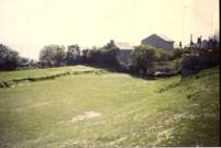
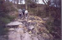
Early in 1993, tension cracks appeared in the gardens of houses on High Street, Bolsover in Derbyshire, and were beginning to affect Old Town Park lower down the escarpment and threaten properties on New Station Road below. All this occurred on the site of a previous landslide in the 1930s, some 10 years or so after the slope had been undermined by coal-mining activities. This had resulted in damage to and subsequent demolition of 4 houses on New Station Road. 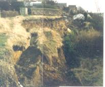 By January 1994, about 3m of the gardens on High Street had dropped 4m, leaving a clear Magnesian Limestone back scar. Steps into the park had been badly disrupted and footpaths in the park were affected by tension cracks higher up and compression ridges up to 0.3m high at the toe of the landslide. Houses on New Station Road were damaged by compression and the 1960s replacements for the earlier demolished houses were under serious threat as the gardens were encroaching onto the level area that had been excavated to construct these houses. The footpath on New Station Road was by now only half its previous width but the gas and water service pipes within it were taken up and placed on surface to remove the risk of breakage and significant threat to life should this occur. Partial stabilisation works including the installation of drainage in the slide mass in Old Town Park were funded by the Department of the Environment using derelict land grant.
- Landsliding at Shanklin, Isle of Wight
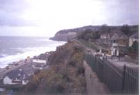 The Esplanade at Shanklin, Isle of Wight, is backed by an abandoned sea cliff of Greensand 20-30m high. The Greensand is permeable and contains clay layers which result in seepage out of the face and occasional slabbing off of both small and large amounts of material and accumulation at the foot of the cliff of talus heaps. In parts these landslides have undermined the cliff-top path on land owned by the local council and threaten roads and properties both above and below the cliff. As a result South Wight Borough Council commissioned a hazard assessment and initiated stabilisation works in the priority areas to remove the shrubby vegetation, batter back the upper parts of the cliff and reseed the battered slopes on protective matting.
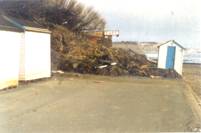
In 2001 a further incident occurred when a talus heap behind a hotel on the Esplanade slid into the hotel while the guests were dining. Fortunately no-one was badly injured, the only person trapped having the slide debris on top of his artificial leg.
3. Landsliding at Ventnor, Isle of Wight
The theme park at Blackgang Chine is well known to be gradually getting smaller as more land falls into the sea on what is one of the largest coastal landslide complexes in England. In 1994. at Castle Haven in Niton, the grounds of some properties slid down hill leaving back-scars with intermediate terraces behind.
 The town of Ventnor has a population of about 7,000 almost all of whom live on this undercliff landslide complex. In upper Ventnor there is a distinct graben where the land between two landslide blocks has subsided as the lower block has moved downhill. This graben continues across the main road into the town, which has had continual repairs over the last 40 years, and damaged walls and properties, which have now been demolished. Following a study funded by the Department of the Environment which looked at ground behaviour and damage to properties in central Ventnor planning policies are now in place to prevent development in hazardous areas, particularly those between landslide blocks. The techniques developed during this study have been applied more widely by the council to the rest of Ventnor and to other areas of the Isle of Wight.
4. Landsliding at Luccombe, Isle of Wight
The small fishing village of Luccombe, at the mouth of Luccombe Chine was destroyed by “The great landslide” of 1910 and a replacement village was eventually constructed on top of the cliffs 90m above the sea. Unfortunately the presence of landslide scars within the area of the village was not noticed and the Luccombe Road was cut by landsliding in 1951. In 1961, further landsliding resulted in the demolition of 3 or 4 houses. In the winter of 1987-88, further landsliding occurred, damaging several houses in the village.
 An investigation of this landslide was carried out as an extension to the DOE’s Ventnor study, which concluded that the landslide was deep-seated within the Gault Clay overlying the Sandrock of the cliffs below the village. While these cliffs are being eroded, the influence of coastal erosion on the landslide is minimal and the landslide is driven by water on the steep Gault Clay slopes beneath the Chalk capping of the downs. Sources of water are both natural (groundwater from the Chalk) and artificial (from roof and foul drainage and water supply pipes. The trigger for movement was heavy rainfall at a time when water levels in the ground were already high. Following these events, although some houses had to be demolished, the rest of the village remains in place but has now had mains sewerage installed to help reduce water in the ground.
What can we do about landslides?
The first essential is to know the scale of the problem and the DOE carried out a study of Landsliding in Great Britain (DKC Jones & EM Lee, 1994, HMSO) which looked at the distribution, nature, causes, risks, investigation, monitoring and stabilisation of landslides. Maps were produced of the distribution of about 8,500 landslides recorded in the published literature and their association with particular landslide-prone solid geological strata. Locally, investigations have been carried out on landslides and slope steepness during applied geological mapping projects and as part of the investigations for development projects. The DOE has issued guidance to local authority planners on Development on unstable land (PPG 14, 1990; PPG14 Annex 1 Landslides and planning, 1996).
These emphasise the need for planning authorities to take account of landslides in reaching their decisions and for applicants for planning permission to submit with their application sufficient information to demonstrate that the development they are proposing will not be affected by landslides or cause landsliding elsewhere. If necessary, a stability report should demonstrate the level of risks involved and how they will be managed in the design, construction and operation of developments proposed.
Surface indications of instability can include features such as hummocky ground, bulges in slopes, trees with distorted trunks, tilted telegraph poles, bulging or cracked walls, tension cracks in path or the ground generally and steep banks which may be an old landslide head-scarp. Development itself can introduce factors which are detrimental to stability, such as cut-and-fill to level a slope for construction removing support from the slope above and loading the slope below and increasing the amount of water in the ground by removing vegetation, directing roof drainage into the ground or through leaking pipes.
A number of methods can be used to stabilise hill slopes, including re-profiling to add weight to the toe and remove weight from the head of the slope, introducing drainage above and in the slope and introducing shear keys to tie the ground back. Face-support methods for natural cliffs and old quarry faces can include rock bolts, mesh and ground anchors.
Conclusion
Landslides occur widely throughout the world, where the relief and climate often results in a more dynamic geomorphological situation than in Britain. However, we do have a lot of landslides, though many are a relic of more active conditions during and just after the last glaciation. Coastal erosion, water and human interference appear to be the main causes of recent movements of slopes by landsliding. It is therefore doubly important that the risks arising should be recognised and taken into account in deciding where new developments (roads, houses etc) should be located. However, landsliding is also responsible for many of the coastal features that are attractive to visitors, including keeping the white cliffs of Dover white (they would otherwise become vegetated) and releasing fossils from intensely collected areas such as the Jurassic coast of Dorset.