Harrow and Hillingdon Geological Society
Aspects of Gypsum
Home | Monthly Meetings | Field Trips | Exhibitions | Other Activities | Members Pages | Useful Links
ASPECTS OF GYPSUM
Dr David Brook OBE
INTRODUCTION
Gypsum (CaSO 4.2H 2O) and anhydrite (CaSO 4) are the naturally occurring forms of calcium sulphate.
Gypsum, when pure is colourless to white, has a perfect platy cleavage giving rise to a tabular habit and a hardness of 1.5-2. It is slightly soluble in water but otherwise inert, resistant to chemical change and markedly flame-resistant because water is driven off on heating. Anhydrite occurs as massive, usually granular aggregates that are white to pale grey, blue, brown or red with a hardness of 3-3.5. Selenite is a transparent or translucent crystalline variety of gypsum with a tabular habit. The compact massive fine-grained form used as ornamental stone is alabaster.
ORIGIN
The largest and commercially most important deposits of gypsum and anhydrite occur as beds, which may persist over considerable areas with little change in quality or thickness. They are frequently interbedded with limestones, shales, mudstones, clays, dolomite, rock salt and locally sylvite. Gypsum and anhydrite are among the first minerals to precipitate from evaporating sea water with about 0.14% CaSO 4. Further evaporation leads to precipitation of halite and sylvite.
RESOURCES
Gypsum and anhydrite are widely distributed in England, largely in the Permian and Triassic and, to a lesser extent, the Jurassic. Commercial deposits of gypsum are restricted to the Upper Permian of Cumbria, the Mercia Mudstones of Nottinghamshire, Leicestershire and Staffordshire and the Jurassic in East Sussex. Anhydrite was formerly mined in Cleveland and West Cumbria and gypsum was mined in North Yorkshire; small gypsum operations were formerly active in Derbyshire, Somerset and South Glamorgan.
Synthetic gypsum is produced as a by-product of several industrial processes the most important being desulphogypsum, from the desulphurisation of flue gases at coal-fired power stations.
RESERVES
Total permitted reserves of gypsum and anhydrite in Britain exceed 50M tonnes, mainly in East Sussex and Leicestershire
Opencast reserves of gypsum in Nottinghamshire are about 10Mt, of which about half have the benefit of planning permission.
EXTRACTION & PROCESSING
Opencast working is now confined to Nottinghamshire. Waste:mineral ratios can be as high as 15:1, with the waste used to reclaim the void.
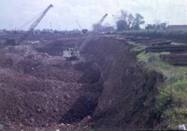
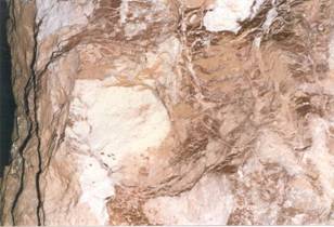
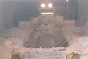
Hawton pit, near Newark 1966 Hawton Pit near Newark 1966
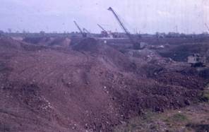
Kilvington tips near Newaark 1966 Plasterboard plant & restoration 1966
Gypsum and anhydrite are largely produced by underground mining using room and pillar methods with up to 75% extraction. Continuous miners are replacing drill & blast techniques because of their lesser impact, allowing better resource recovery in conjunction with selective mining.
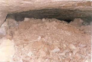
Gypsum nodules – Marblaegis mine Blast pile – Marblaegis mine
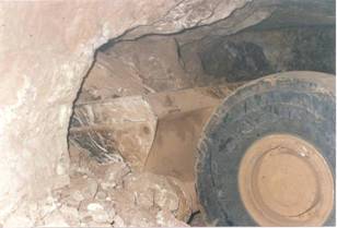
Loading out – Marblaegis mine Mine heading – Marblaegis mine
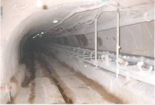
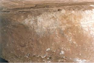
Underground crusher – Marblaegis mine Adit conveyor– Marblaegis mine
Gypsum is generally only screened to remove fines. For plaster, gypsum powder is calcined in large kettles at temperatures of 150 o-165 oC to drive off about three quarters of the combined water. Plaster is mixed with water to produce a slurry, which is then encased in durable paper liners, cut to required length and passed through a kiln to remove excess water.
USES
The most important use of gypsum is in the manufacture of building plaster (35%) and plasterboard (35%) and as a retarder in Portland cement (27%). Anhydrite is no longer produced but it was formerly used in the manufacture of sulphuric acid (and cement) at Whitehaven and for the fertiliser ammonium sulphate.
PRODUCTION
Gypsum production in England began in the 1250s after Henry III introduced gypsum plaster following a visit to Paris. The principal gypsum deposits in Nottinghamshire came into production in the mid-1800s. In Cumbria, gypsum was worked as early as 1828 and underground mining started in 1895. Gypsum was formerly produced south of Whitehaven but mining ceased in 1908. In Northern Ireland, gypsum was produced as early as 1812 and the last recorded output was in 1951.
Anhydrite was produced in Cumbria and Cleveland from 1923 to the 1970s.
5 companies operated gypsum and anhydrite mines and quarries in 1974 but by 1994 all were operated by BPB Industries Ltd (British Gypsum). In 2004, gypsum production was taking place in Cumbria, Staffordshire; Nottinghamshire, Leicestershire and East Sussex; with desulphogypsum at the Trent and Ouse valley power stations and titanogypsum at Grimsby.
Plasterboard plants using indigenous and synthetic gypsum were located in Cumbria, North Yorkshire, Nottinghamshire, Leicestershire and East Sussex. Plants using imported gypsum were located near ports in Gloucestershire; Kent and Lincolnshire.
TRADE
Until the late 1980s, the UK was largely self-sufficient in gypsum, with production from 1970 to the mid-1980s of about 4M tonnes per year. Since then, imports have increased to supply plasterboard plants operated by companies with no access to indigenous reserves. Flue-gas desulphurisation of coal burning power plants also produces significant quantities of gypsum.
While gypsum is a relatively low-priced mineral, it is mainly used captively in the manufacture of plaster and plasterboard or sold for cement manufacture. The value of gypsum production has been estimated at £19M in 2004, while sales of the principal products, plaster and plasterboard totalled £630M in 2004. Sales of cement, of which gypsum is a relatively minor component were £831M.
WORLD PRODUCTION
Worldwide gypsum production is believed to be 107-110M tonnes per year. Over 90 countries produce gypsum though only 6 ( USA, China, Thailand, Iran, Canada & Spain) account for over half total output. These production figures do not include by-product gypsum so overall consumption may be considerably greater than recorded production. Annual world consumption of plasterboard exceeds 5Mm 2, 55% in North America, 20% in Europe and 25% in the rest of the world, almost half of which is consumed by Japan.
Leading producers are :
BPB , the world’s leading producer of gypsum plasterboard & plasters, with 90 manufacturing sites in more than 50 countries; it has 20% of the market with global plasterboard sales exceeding 1,000M m 2.
Knauf Group of Germany has over 100 plants in Europe, Asia, USA & South America; it mines over 5Mtpa of gypsum from some 53 quarries and 12 pits in 23 countries; global plasterboard capacity exceeds 800M m 2.
Lafarge , based in France operates production facilities in 24 countries and has 38 gypsum production sites in Europe, 7 in North America, 2 in North Africa/Middle East and 15 in Asia; plasterboard capacity stands at 900M m 2.
US Gypsum has 46 plants in North America and mines or quarries gypsum from 15 sites and produces 10Mtpa of crude gypsum; it produces about one third of US wallboard.
National Gypsum has more than 40 operations in the USA and Canada.
ASSESSMENT OF SUBSIDENCE ARISING FROM GYPSUM DISSOLUTION
INTRODUCTION – SUBSIDENCE IN RIPON
Gypsum in the Permian rocks of the Ripon area was originally precipitated from warm, shallow sea water. As it became buried by younger rocks, gypsum dehydrated and formed anhydrite. With the removal of overburden by erosion, anhydrite reacted with groundwater to form secondary gypsum in the near-surface zone.
With continued exposure to flowing groundwater not saturated in calcium sulphate, gypsum dissolves rapidly leading to formation of solution-widened joints and fissures with in some cases major underground cavities or cave systems. Gradual caving of weaker or thinly bedded strata and/or more abrupt failure of thickly bedded rocks causes cavities to propagate upwards to surface, leading to subsidence hollows in open fields and subsidence damage to houses.
Areas susceptible to gypsum dissolution are broadly constrained by the limits of outcrop of gypsum-bearing strata to the west and the limits beyond which gypsum beds give way to unaltered anhydrite at depth in the east.
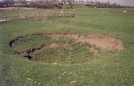
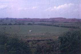
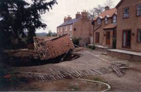
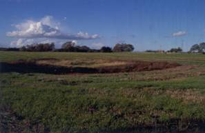
Subsidence hollow 1834 collapse hole
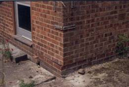
Movement along damp-proof course Collapse of detached garage
GEOLOGY
The Ripon area includes the full sequence of Permian rocks overlain by variable thicknesses of superficial (drift) deposits. Solid strata have a gentle easterly dip exposing the rocks in a stratigraphical sequence from east to west:
- The Cadeby Formation (Lower Magnesian Limestone) lies unconformably on Carboniferous rocks. It is 40-65m thick at outcrop and thickens to 90m to the east.
- The Edlington Formation (Middle Permian Marl) comprises interbedded mudstones and gypsum passing down into massively bedded gypsum and anhydrite at the base. Both the formation and the gypsum beds thicken eastwards, with 20m of anhydrite overlying 13m of gypsum at Ure Bank.
- The Brotherton Formation (Upper Magnesian Limestone) is 10-14m thick and may thicken to 20m further east.
-
The Roxby Formation (Upper Permian Marl) is similar to the Edlington formation with a 10m-thick basal gypsum unit. The formation is 10-18m thick, increasing to the east to 30-40m.
-
Substantial thicknesses of the Sherwood Sandstone Group occur to the east of Ripon.
Superficial deposits comprise
- Pre-Devensian – a buried valley beneath the modern River Ure is infilled with coarse-grained fluvial and fluvio-glacial sediments, sandy gravels, cobbles and boulders, locally cemented by calcium carbonate precipitated from groundwater to form hard conglomerates.
- The Devensian is predominantly glacial till from <1 to >30m thick comprising stiff clays, with glacio-fluvial outwash sediments on sides of main valleys.
- Post-glacial river terraces occur along Skell and Laver valleys with isolated remnants in the Ure valley.
- Alluvial sediments occur beneath contemporary flood plains, typically comprising a basal sand and gravel (8m thick in Ure valley) overlain by finer-grained deposits (1-2m thick in Ure valley).
- Holocene peat deposits have accumulated in subsidence hollows and other areas of poor drainage, including flood plains.
GEOMORPHOLOGY
Substantial long-term foundering has occurred along the western and to a lesser extent the eastern margins of the deep buried valley beneath the modern River Ure. This is a relatively recent feature superimposed on the more general east-west thinning of gypsum since the formation of the valley.
CONCEPTUAL MODEL OF GYPSUM DISSOLUTION
Hydrogeological factors are fundamental to understanding the distribution of gypsum dissolution. Regional groundwater movements are predominantly east to west with base levels provided by the Vale of York. However, a local base-level is provided by the River Ure and its hydraulic connections created by the gravel-filled buried valley, which allows interception of regional groundwater flows.
On the west side of the valley, groundwater under artesian pressure in the Cadeby Formation moves upwards through the massive gypsum at the base of the Edlington Formation and into sand and gravel in the buried valley. Within a limited zone on the east side, groundwater in the Brotherton Formation is also drawn towards the buried valley and moves up through gypsum at the base of the Roxby Formation.
Together, these mechanisms are responsible for the high intensities of gypsum dissolution beneath and at the margins of the buried valley and for localised concentration of post-glacial subsidence.
It is important to emphasise that there is only one event per year on average over an area of over 30km 2, they are largely in open countryside and cause only minor damage when they do affect buildings -- and much of that is due to compression of peat in older filled hollows. There is thus a very low property risk, much lower than that of flooding in the Ure valley.
ENGINEERING RESPONSE
Engineering responses involve
- investigation , particularly to distinguish the occurrence of gypsum, which may in some instances be mistaken for limestone; and
- mitigation . For major structures, deep large-diameter end-bearing piles founded in the Cadeby Formation limestone below the lowest gypsum may be the only solution. For lesser structures then it is crucial that structural rigidity is provided through the use of reinforced foundations. Grouting of cavities may pose problems by changing the hydrogeological flow pattern, resulting in dissolution taking place elsewhere.
PLANNING RESPONSE
Planning response is through a planning development control map subdividing the area into 3 zones:
- In area A, to the west, no gypsum is present, there are no constraints on local plan proposals & no planning control requirements related to gypsum. Building control measures may be needed if unexpected gypsum is encountered
- In area B, to the east, thick gypsum is present at depth but it is rarely affected by dissolution. Minor constraints may be imposed on local plan proposals and ground stability report may be required by condition on planning permissions.
- In area C, gypsum is present at shallow depth and susceptible to localised dissolution. Significant constraints may be imposed on local plan proposals and a ground condition report is normally before determination of planning applications and consents may be conditional on the implementation of approved mitigation measures.
All ground stability reports are required to be carried out by a suitably experienced geotechnical specialist, and confirmation is required that any previous ground investigation reports have been consulted, that an adequate ground investigation has been carried out and whether massive gypsum beds or cavities or foundered strata have been located and assessed for their potential effect on subsidence.
GYPSUM DISSOLUTION BEYOND THE RIPON AREA
Gypsum occurs in the Permian both northward to Darlington and Hartlepool and southward to Doncaster.
South of Darlington, at Hell’s Kettles, catastrophic collapse occurred in 1179 creating 4 subsidence hollows up to 35m diameter and 6m deep. It appears to be associated with the margins of the buried valley of the River Tees. Other minor subsidence is possibly in part due to gypsum, with shallow depressions, (generally less than 1m deep) up to several hundred metres in diameter.
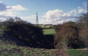
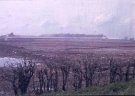
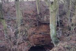
Subsidence hollow, Church Fenton The Punch Bowl, Burton Salmon
The Ripon to Bedale area has widespread evidence for post-glacial subsidence but little evidence of ongoing activity and possibly not all the features are due to gypsum. In the Sherburn area, a subsidence hollow north of Church Fenton may be kettle holes. Near Knottingley, the Punchbowl at Burton Salmon and other hollows may lie along the line of a dry valley.